- Home
- Adventure Challenges
- Jeep Glossary
- Jeep Types
- Jeep Clubs
- Georgia Traverse
- Georgia Adventure Trail
- Popular Trails
- Forest Service Roads
- Off-Road Parks
- Jeep Badge Trails
- Fun Jeep Drives
- Off-Roading Basics
- Off-Road/Repair Shops
- Recovery & Support
- Content Creators
- Jeep Dealerships
- Navigation
- Destinations
- Gifts/Products
- Useful Maps
- Club Spotlight
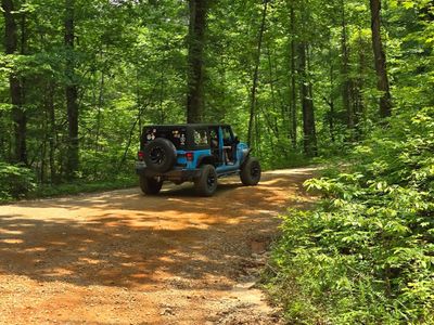
Popular Forest Service Roads in North Georgia
Forest Service Roads
Explore North Georgia’s backcountry byway network with these Forest Service Roads around Helen, Dahlonega, Toccoa, Tallulah Falls, and Clayton. Each route offers a mix of scenic drives, creek crossings, and rugged mountain climbs for Jeep and off-road enthusiasts. Always check the latest Forest Service maps for seasonal closures and current trail conditions before heading out. NOTE: This is not a complete list. There are dozens of roads.
🧭 Before You Go
📍 Download current maps: Get the latest Chattahoochee–Oconee National Forest MVUM to verify which roads are open to vehicles.
☎️ Contact local ranger districts: Always confirm gate status, closures, and weather impacts before heading out.
⚠️ Important reminders:
- Seasonal open/close dates, water levels, and terrain conditions can change quickly.
- Higher difficulty ratings often require high-clearance 4×4s, recovery gear, and off-road experience.
- Many routes are single-lane or two-lane forest roads with limited turnarounds — drive with caution and respect other users.
- Pack out all trash and tread lightly to preserve Georgia’s mountain backroads for future explorers.
Helen Area
Corbin Creek Road (FSR #698)
From Helen: Take GA-75 N → Tray Mountain Road (FSR #79).
Description: ~10 miles of graded gravel Forest Service road climbing through lush terrain and connecting toward Tray Mountain.
Vehicles: 4x4s, SUVs, dual-sport motorcycles.
Difficulty: 2–2.5 (Easy–Moderate).
Season: Typically open Mar. 10–Jan. 2 (verify seasonal gates).
Notes: Scenic forest drive; some users report gates or washouts.
Indian Grave Gap Road (FSR #283)
From Helen: Take GA-75 N approximately 13 miles → Indian Grave Gap entrance.
Description: ~4-mile one-way road with mild water crossings and access to multiple hiking trailheads.
Vehicles: 4x4s, high-clearance SUVs, ATVs.
Difficulty: 2.5 (Easy–Moderate).
Season: Mar. 10–Jan. 2.
Notes: Connects to the Tray Mountain area; popular during leaf season.
Grapevine Road (FSR #839)
Accessed from Indian Grave Gap Road.
Description: ~2.5-mile spur trail ending at a creek crossing; rugged, narrow and remote.
Vehicles: High-clearance 4x4s only.
Difficulty: 4.5 (Difficult).
Season: Short seasonal openings (typically Nov.–Dec.; verify status).
Notes: No turnaround for long vehicles; limited information available.
Wildcat Road (FSR #26-1)
From GA-197 → Wildcat Creek area.
Description: ~7.5-mile road following Wildcat Creek with forest canopy and streamside pull-offs.
Vehicles: 4x4s, SUVs, adventure motorcycles.
Difficulty: 2.5–3 (Moderate).
Season: May be closed at this time.
Notes: Popular with anglers and campers.
Dick’s Creek Road (FSR #34)
From GA-197 N → Kennesaw Road.
Description: ~4-mile dead-end road featuring approximately 14 creek fords.
Vehicles: High-clearance 4x4s recommended.
Difficulty: 2.5–3 (Moderate).
Season: Open year-round.
Notes: Frequent water crossings; scenic but remote.
Poplar Stump & Chattahoochee River Road (FSR #44)
From GA-75A approximately 0.1 mile west of GA-75.
Description: ~14-mile scenic road paralleling creeks and campsites in the Chattahoochee National Forest.
Vehicles: 4x4s, SUVs.
Difficulty: 2–2.5 (Easy).
Season: Open year-round.
Amenities: Primitive campsites, stream views.
Trail Ridge Road (FSR #44B)
Approximately 6.6 miles northwest up Chattahoochee River Road from GA-75A.
Description: ~6.2-mile loop with steep hill climbs and descents; connects back to FSR 44.
Vehicles: Lifted 4x4s only.
Difficulty: 4.5–5 (Difficult).
Season: Limited seasonal windows (verify via MVUM).
Notes: Excellent off-road challenge route.
White Oak Gap Road (FSR #244)
Approximately 2.2 miles northeast of GA-75A junction.
Description: ~5-mile gravel road ending in a forest clearing with moderate grades and two water crossings.
Vehicles: 4x4s, adventure motorcycles.
Difficulty: 4–4.5 (Moderate–Difficult).
Season: Open year-round.
Amenities: Trailhead restroom at start; strong fall color views.
Lookout Mountain Loop (FSR #163)
Junction of U.S. 76 and Lookout Mountain Scenic Highway.
Description: ~5.6-mile loop with steep grades and a rocky 0.4-mile spur.
Vehicles: 4x4s; short wheelbase recommended.
Difficulty: 4–4.5 (main loop), 5 (spur).
Season: Open year-round.
Notes: Tight turns; scenic mountain drive.
Dahlonega Area
FSR #46 (Amicalola Creek Road)
From Dahlonega: Take GA-52 W → Nimblewill Road → follow signs to FSR 46 toward Amicalola Falls State Park campground.
Description: ~4.3 miles of mixed dirt and gravel transitioning from narrow forest road to wider hard-pack near the state park.
Vehicles: 4x4s, SUVs, SxS, dual-sport bikes.
Difficulty: Easy.
Season: Spring–Fall; check winter closures.
Notes: Shaded in summer; better views in fall. Trail exits into Amicalola Falls State Park campground.
FSR #28-1
From Atlanta: GA-400 N to Dahlonega → forest roads into Blue Ridge WMA.
Description: Lesser-used gravel Forest Service road with ridgeline and valley views.
Vehicles: High-clearance 4x4s, rugged SUVs.
Difficulty: Easy–Moderate.
Season: Year-round.
FSR #77 (Winding Stair Gap Road)
From Dahlonega: GA-60 north → connect with FSR #28-1 near Nimblewill Church Road.
Description: ~5 miles one-way through ridge country with ~1,000 feet of elevation gain.
Vehicles: 4x4s, high-clearance SUVs.
Difficulty: 2 (Easy).
Season: Open year-round.
FSR #42 (Appalachian Blue Ridge Road)
From intersection with FSR #69 (Rock Creek Road).
Description: ~3.4 miles one-way along a scenic ridge with ample pull-offs.
Vehicles: 4x4s, adventure SUVs.
Difficulty: 1 (Easy).
Season: Open year-round.
FSR #55 (Grassy Gap Road)
From intersection with Black Mountain Road.
Description: ~3.9 miles one-way, steadily uphill and rocky.
Vehicles: Lifted 4x4s recommended.
Difficulty: 3.5 (Moderately Difficult).
Season: Open year-round.
FSR #42A (Hightower Gap / Hawk Mountain Road)
Off FSR #42.
Description: ~0.9-mile dead-end with rough, rocky surface near the end.
Vehicles: High-clearance 4x4s only.
Difficulty: 4–5 (Difficult).
Season: Open year-round.
FSR #69 (Rock Creek Road)
From GA-60 junction.
Description: ~7.9 miles one-way following Rock Creek to Rock Creek Lake and National Fish Hatchery.
Vehicles: 4x4s, SUVs.
Difficulty: 2.5 (Moderate).
Season: Open year-round.
FSR #69A
From intersection with FSR #69.
Description: ~1.5-mile narrow two-rut dead-end trail.
Vehicles: Short-wheelbase 4x4s only.
Difficulty: 4.5–5 (Difficult).
Season: Mar. 10–Jan. 2.
FSR #77A (Jones Creek Road)
From Dahlonega: GA-52 W → Nimblewill Gap Road → Winding Stair Gap Road → FSR 77A.
Description: ~2.1-mile out-and-back alongside Jones Creek with shallow water crossing.
Vehicles: High-clearance SUVs, 4x4s, SxS.
Difficulty: 2 (Easy–Moderate when wet).
Season: Spring–Fall.
FSR #83 (Bull Mountain Road)
From Dahlonega: GA-52 W → Nimblewill Gap Road → Winding Stair Gap Road.
Description: ~1.6 miles of gravel and clay with occasional ruts.
Vehicles: SUVs, 4x4s, SxS, ATVs, dirt bikes.
Difficulty: 2 (Easy).
Season: Spring–Fall (verify gates).
FSR #141 (Montgomery Creek)
From Dahlonega: GA-52 E → Grizzle Road → FSR 141 loop.
Description: ~5.7-mile mostly dirt loop with shallow water crossing and fishing access.
Vehicles: SUVs, 4x4s, SxS, ATVs.
Difficulty: 1 (Easy).
Season: Year-round.
Notes: Beginner-friendly; watch traction after rain.
FSR #333
Description: ~3 miles one-way with ruts and potholes; access to the Toccoa River Swinging Bridge via Benton MacKaye Trail.
Vehicles: 4x4s.
Difficulty: 3.5–4 (Moderate–Difficult).
Season: Mar. 10–Jan. 2.
Blairsville Area
FSR #236 (Cavender Gap Road)
From Blairsville: GA-180 → Cavender Gap Road → continue north toward Cooper Creek.
Description: ~2.9 miles of well-maintained gravel connecting Cavender Gap to Cooper Creek Campground.
Vehicles: High-clearance 2WD, SUVs, 4x4s.
Difficulty: 2 (Easy).
Season: Year-round.
Blue Ridge/Ellijay/Chatsworth Area
Stamp Ridge
From Ellijay: GA-52 W → Forest Service roads toward Stamp Ridge.
Description: ~10 miles of lightly traveled out-and-back gravel road with ridgeline views; final 0.5 mile becomes narrow single-track dirt.
Vehicles: High-clearance 4x4s, SUVs, SxS (60").
Difficulty: Easy.
Season: Spring–Fall.
Bush Head Gap Road
From Blue Ridge: Take GA-5/GA-515 N → connect to Forest Service roads near the Georgia Traverse (FS 86) → follow signage toward Bush Head Gap Road.
Description: ~4.7 miles of narrow, overgrown Forest Service road that runs as a short exploration detour off the Georgia Traverse. The route is generally easy with no major obstacles, but includes one steeper section with small rock ledges and occasional ruts/off-camber sections.
Vehicles: High-clearance 4x4s, SUVs.
Difficulty: Easy (technical rating 2/10)
Season: Year-round
Notes: Narrow and heavily overgrown—expect pinstriping, especially in full-size vehicles. A Forest Service berm blocks the road about two-thirds in, making this an out-and-back. Limited, lightly used camping near the end and at Hudson Gap; conditions vary with overgrowth, mud and occasional downed trees.
Mulberry Gap Road (FSR 18)
From Ellijay: Take GA-52 W → turn onto local Forest Service roads toward Mulberry Gap → follow signage for Mulberry Gap Road (FSR 18).
Description: ~2.2 miles of well-maintained, full-width gravel Forest Service road providing access to popular mountain biking and hiking trails in the Mulberry Gap area. The drive features light scenery along the way, including an old fire truck, stacked rock formations, mountain laurel and a small flowing branch beside sections of the road.
Vehicles: 4x4s, SUVs, AWD vehicles.
Difficulty: Easy
Season: Year-round
Notes: Smooth, beginner-friendly gravel road with minimal obstacles. Expect cyclists and hikers sharing the area, especially during peak seasons; drive slowly and courteously. Dusty conditions are common in dry weather.
Hickorynut Gap (FSR 797)
From Chatsworth: Take GA-2 → turn onto Devils Den Road → follow Forest Service signage to Hickorynut Gap Road (FSR 797) near the edge of the Cohutta Wilderness.
Description: ~5.9 miles of in-and-out Forest Service road running along the boundary of the Cohutta Wilderness within the Chattahoochee–Oconee National Forest. The route is longer than many area FSRs and gradually climbs in elevation, with changing conditions as you gain altitude.
Vehicles: High-clearance 4x4s, SUVs, AWD vehicles.
Difficulty: Easy–Moderate (technical rating 3/10)
Season: Summer (open year-round; conditions vary by weather)
Notes: Mostly a level 2 road with a few sections of erosion and muddy spots that increase difficulty, especially at higher elevations where water tends to collect. Fog can set in quickly as you climb, and snow or ice is possible in colder months. Proper tires are recommended. Access is typically via Devils Den Road; gates may be locked from other approach routes.
631 – Tatum Lead
From Ellijay: Take GA-52 east along the scenic byway → continue past the overlook; the trailhead is on the right just beyond the overlook.
Description: ~7.4 miles of full-width Forest Service road running through the northern end of the Chattahoochee National Forest, with access granted through private property at the entrance. The route travels under a dense forest canopy and leads toward the Rock Creek OHV trail system, ending at a dead-end turnaround rather than through-travel.
Vehicles: High-clearance 4x4s, SUVs, SxS (60"), ATVs (50"), dirt bikes.
Difficulty: Easy (technical rating 2/10)
Season: Spring–Fall
Notes: Suitable for high-clearance 2WD in dry conditions, but good tires are recommended due to slick rock when wet. Trail is very narrow with heavy vegetation—pinstriping is likely. Limited pull-offs make passing difficult, and fallen trees are common after storms; carrying a saw is advised. The trail dead-ends near the Rock Creek OHV area (OHV trails closed Jan. 1–Mar. 31). Turnaround space is available at the end, but there is no room for trailer parking along the route.
Flat Top Mountain (FSR 64A)
From Ellijay: Take local Forest Service roads toward Flat Top Mountain → follow signage for FSR 64A.
Description: ~1.7 miles of short but engaging Forest Service road featuring rolling hill climbs and quick descents that give the route a “rollercoaster” feel. The drive includes rocky sections, uneven ruts and scenic overlooks, finishing at a large campsite area at the top.
Vehicles: High-clearance 4x4s, SUVs.
Difficulty: Easy (technical rating 3/10)
Season: Year-round
Notes: Primarily a narrow, single-vehicle-width route with no turnaround until the top. The hill climb can be slick when wet, but many vehicles make it without 4WD in dry conditions. Expect rocky, rutted sections and limited sightlines over crests. A large campsite sits at the summit, though conditions can be muddy and bugs common in warmer months; wildlife activity, including bears, has been reported in the area.
Peeples Lake (Trail 3)
From Chatsworth: Begin within the city of Chatsworth → follow local dirt roads north toward Peeples Lake and the Rock Creek OHV trailhead.
Description: ~3.5 miles of full-width dirt road running from a residential area in Chatsworth to the parking area for the Rock Creek OHV trail system (50" and under). The route sees steady traffic, including vehicles towing trailers, and features rutted, uneven sections from frequent use. A small scenic lake sits along the way, offering a peaceful stop before reaching the trail’s end.
Vehicles: High-clearance 4x4s, SUVs, SxS (60"), ATVs (50"), dirt bikes.
Difficulty: Easy (technical rating 2/10)
Season: Spring–Fall
Notes: Expect heavy vehicle traffic and limited sightlines—approach turns slowly. The dirt surface can feel rough and “cobblestoned” due to ruts, especially during dry or high-use periods. A gate prevents vehicle access directly to the water, but the lake remains accessible on foot for fishing or carrying kayaks. This route passes near the historic Trail of Tears corridor, adding cultural significance to an otherwise relaxed and scenic drive.
Springer Mountain Trail
From Dahlonega / Blue Ridge WMA: Access via Doublehead Gap Road near the Blue Ridge Wildlife Management Area, or from the south via Winding Stair Mountain Trail connecting north to the Blue Ridge roads near Springer Mountain.
Description: ~9.3 miles of full-width Forest Service road traveling through the North Georgia mountains and passing the southern terminus of the Appalachian Trail at Springer Mountain. The route is primarily dirt and gravel, generally wide enough for two vehicles, with small spur roads leading to dispersed camping areas along the way.
Vehicles: High-clearance 4x4s, SUVs, SxS (60"), ATVs (50"), dirt bikes.
Difficulty: Easy (technical rating 1/10)
Season: Year-round
Notes: Beginner-friendly with loose gravel and minor ruts, though rain can increase rutting in spots. Summer foliage limits long-range views, while winter and late fall offer expansive mountain vistas. Expect some narrow sections and shared use near trailheads and campsites; drive cautiously and yield as needed.
FS-68 – Lake Conasauga
From Eton: Take US-411 → Mill Creek Road / FS-630 → FS-17 (West Cowpen Road) → turn right onto FS-68 following Lake Conasauga signage.
Description: ~1.9 miles of easy, full-width Forest Service road providing access to the Lake Conasauga Recreation Area within the Cohutta Wilderness of the Chattahoochee National Forest. Entry via FS-68 leads to multiple spurs, including FS-68A (day-use area), FS-68C (Lake Conasauga overlook), FS-49 (access to additional trails), and FS-68D, which serves the boat ramp and campground.
Vehicles: High-clearance 4x4s, SUVs.
Difficulty: Easy (technical rating 1/10)
Season: Spring–Fall
Notes: Accessible to most legally tagged full-size vehicles. Due to limited turnaround space, vehicles towing boat trailers should use FS-68D only. Ideal for a relaxed outing with opportunities for camping, boating and lakeside exploration.
Muskrat Creek Road
From Chatsworth: Take Old CCC Camp Road → follow signage to Muskrat Creek Road within the Cohutta area.
Description: ~4.9 miles of narrow, single-lane dirt road restricted to street-legal vehicles only (no OHVs or ATVs). The route features blind corners, low-hanging branches, shallow side ruts and occasional embedded rock. At a three-way intersection, access is available to the Windy Gap Trailhead; beyond this point the road narrows further, becomes rougher with rain ruts, and sees less traffic before ending near Trails 218A and 218B.
Vehicles: High-clearance 4x4s, SUVs.
Difficulty: Easy (technical rating 2/10)
Season: Spring–Fall
Notes: Despite the easy rating, the road’s narrow width and overgrowth make it unsuitable for RVs and larger vehicles. 2WD is typically sufficient with adequate clearance, though articulation may be needed in rutted sections. Expect limited sightlines, occasional downed trees and rougher conditions after rain; check gate status before heading out.
Noontootla
From Blue Ridge WMA: Access from the north via Doublehead Gap Road, or from the south via Winding Stair Mountain Trail; veer left onto Noontootla at the signed junction.
Description: ~8.1 miles of beginner-friendly, full-width Forest Service road running alongside Noontootla Creek and Chester Creek, offering numerous designated group and family car-camping areas along the west side of the road. The route is primarily loose gravel and dirt with minimal elevation change and frequent pull-offs, making it ideal for relaxed drives and camping-focused trips.
Vehicles: High-clearance 4x4s, SUVs, SxS (60"), ATVs (50"), dirt bikes.
Difficulty: Easy (technical rating 1/10)
Season: Year-round
Notes: Extremely popular during warm weather—arrive early for camping as sites fill quickly. Most of the road is wide enough for two vehicles with plenty of turnaround options. Expect light ruts, washboarding and minor exposed rock after rain. Respect posted camping signs. The Appalachian Trail crosses nearby, offering easy hiking access from the road.
Hiawassee Area
Black Mountain Road (FSR #139)
From Hiawassee: GA-75 N → Unicoi Gap → access FSR 139.
Description: ~3.4 miles of gravel/dirt climbing near the summit of Black Mountain (1,509 ft).
Vehicles: High-clearance 4x4s, SUVs, SxS, ATVs, dirt bikes.
Difficulty: Easy.
Season: Aug. 30–Jan. 9 only.
Notes: Active hunting area; wear blaze orange if hiking.
Tallulah Falls Area
FSR #511 (Water Gauge Road)
From US-441 north of Tallulah Falls.
Description: ~3.6 miles one-way with gentle grades and river views.
Vehicles: 4x4s, SUVs.
Difficulty: 2.5–3 (Moderate).
Season: Open year-round.
FSR #511B (Raven Rock Road)
From FSR #511.
Description: ~1 mile dead-end spur with moderate elevation change.
Vehicles: 4x4s.
Difficulty: 3–3.5 (Moderate).
Season: Open year-round.
Honey Stand Road (FSR #184)
From Cleveland: US-129 N → Forest Service access roads toward Panther Creek.
Description: ~2.2 miles of easy gravel road accessing Panther Creek Trail and Falls.
Vehicles: High-clearance 4x4s, SUVs, SxS, ATVs, dirt bikes.
Difficulty: Easy.
Season: Year-round.
Rock Mountain Road
From Clayton: US-441 N → Camp Creek Road → Rock Mountain Road.
Description: ~2.5 miles of scenic gravel connector near Tallulah Gorge State Park.
Vehicles: 4x4s, SUVs, SxS, ATVs, dirt bikes.
Difficulty: Easy.
Season: Year-round.
Notes: Gentle zig-zags, minor elecation changes, exposed natural rock and water channel runoff along the mountainside.
South Panther Creek Road (FSR #220)
From Cleveland: US-129 N → Black Mountain Road → FSR 220.
Description: ~1.3-mile lightly traveled out-and-back with pine straw, ruts and narrow sections.
Vehicles: High-clearance 4x4s, SUVs, SxS, ATVs, dirt bikes.
Difficulty: Easy (3/10).
Season: Summer.
Toccoa Area
FSR #87 (Guard Camp Road / Sellers Road)
From Ayersville Road.
Description: ~5.2 miles one-way through wildlife management area.
Vehicles: 4x4s, SUVs.
Difficulty: 2–2.5 (Moderate).
Season: Open year-round.
Red Root Road (FSR #92)
From Toccoa: GA-17 N → Lake Russell WMA → FSR 92 toward Mt. Airy.
Description: ~8.1 miles of gravel Forest Service road with camping along the Middle Fork Broad River.
Vehicles: 4x4s, SUVs, AWD vehicles, SxS.
Difficulty: Easy (2/10).
Season: Spring–Fall.
Notes: Washboarding and mud after rain; pack out trash.
Currahee Mountain Road (FSR #62)
From Toccoa: GA-17 N → Lake Russell WMA → FSR 62.
Description: ~2.8 miles climbing Currahee Mountain to scenic overlook.
Vehicles: High-clearance 4x4s, SUVs, AWD vehicles, SxS.
Difficulty: Easy.
Season: Year-round.
Lee Mountain Road (FSR #181)
From Clayton: US-441 N → Forest Service roads toward Lee Mountain.
Description: ~6.9 miles of mostly single-lane gravel and mud with scenic switchbacks.
Vehicles: High-clearance 4x4s, SUVs, SxS.
Difficulty: Easy (2/10).
Season: Fall–Winter.
Locust Stake Road
From Toccoa: Rock Road → Locust Stake Road to Bend’N Hickory Road.
Description: ~2.1 miles of family-friendly gravel through forest foothills.
Vehicles: SUVs, high-clearance 4x4s, AWD vehicles.
Difficulty: Easy.
Season: Year-round.
Notes: Mostly smooth but watch for potholes, washboarding and occasional soft spots after rain.
Georgia Mountain Orchard Road
From Cornelia: Local roads south toward Lake Russell WMA.
Description: ~3.2 miles of smooth gravel entry route into Lake Russell WMA.
Vehicles: 4x4s, SUVs, SxS, ATVs, dirt bikes.
Difficulty: Easy.
Season: Spring–Fall.
Notes: Passable in a 2WD in dru conditions. Gate closures are possible.
Clayton / Rabun County / Warwoman Area
Sandy Ford
From Clayton: Forest Service roads toward the Chattooga River.
Description: ~4.5 miles to a riverside endpoint with dispersed camping.
Vehicles: High-clearance 4x4s, SUVs, AWD vehicles.
Difficulty: Easy.
Season: Year-round.
Notes: Creek crossing near the end can get up to 18 to 20 inches deep after rain. Dusty conditions when dry.
Earls Ford Road
From Clayton: Forest Service roads toward the Chattooga River.
Description: ~3.6-mile out-and-back high-clearance trail with creek crossing and overlook.
Vehicles: High-clearance 4x4s only.
Difficulty: Moderate (6/10).
Season: Year-round.
Note: Generally not recommended for stock vehicles. Heavy rain can result in significantly deeper water. Limited cell service.
Hale Ridge
From Clayton: Warwoman Road → Hale Ridge Road.
Description: ~6.5 miles of gravel and rock connecting Warwoman Road to FS 86.
Vehicles: High-clearance 4x4s, SUVs.
Difficulty: Easy (2/10).
Season: Spring–Summer.
Notes: Generally passable for most vehicles although 2WD may struggle after adverse weather. Limited to no cell service.
Tottery Pole
From Clayton: Warwoman Road → Hale Ridge Road → Tottery Pole Road.
Description: ~4.3 miles paralleling Tottery Pole Creek with dispersed campsites.
Vehicles: High-clearance 4x4s, SUVs.
Difficulty: Easy (2/10).
Season: Spring–Summer.
Notes: Generally passable for most vehicles although 4WD may be needed after adverse weather.
FSR #86 (Overflow Creek Road)
From Warwoman Road approximately 13.7 miles east of Rickman Road / US-441.
Description: ~7.1 miles one-way providing access to multiple backcountry routes.
Vehicles: SUVs, 4x4s.
Difficulty: 3–3.5 (Moderate).
Season: Open year-round.
Sarah’s Creek
From Clayton: Forest Service roads west of town.
Description: ~4.6-mile out-and-back high-clearance trail with creek crossings and technical obstacles near the end.
Vehicles: High-clearance 4x4s only.
Difficulty: Moderate (6/10).
Season: Year-round.
Notes: No cell service. Most technical obstacles near the end. Recent reports indicate some parts have benn closed.